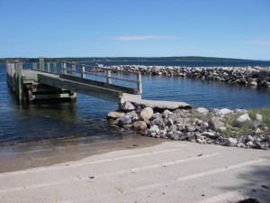
 Location: Slip Road
Shoreline: rocky
Type of access : gravel road to shore
Parking: yes
Government wharf: yes
Public slipway: yes
Public concrete ramp: yes
Topographic reference: 20p/11(Lockeport)
Marine chart # 4241(Lockeport-Cape Sable)or #4209(Lockeport and Shelburne Harbour)
UTM grid: E0311112 Â N4839335
Latitude:N 43° 41.096′ /Longitude: W 65° 20.583’Â
Looking straight across the harbour is the Sandy Point Lighthouse, this is the narrowest place in Shelburne Harbour.
This site has good parking and access although a bit secluded. This makes a good access to paddle to or from McNutt’s Island, making a day trip or overnight. Also from here you can paddle in Shelburne Harbour or explore Birchtown Bay, both making an adventuresome paddle.
