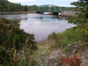
 Location: Tusket River Bridge, rest stop
Shoreline: mud/gravel
Type of access: paved road
Parking: yes
Topographic reference: 20 p/13 (Tusket )
Marine chart # 4244 (Wedgeport and vicinity) very top of marine chart
UTM grid: E 0260426 (60)Â N4860969 (61)
Latitude: N 43° 51.885’ / Longitude: W 65° 58.829′
Public access
In Tusket before this access there is Carl’s Grocery, here you will find a good supply of  groceries/hardware. Ultra Mar gas station nearby.
Easy access from #3 highway Tusket River Bridge, during high tide this makes a good paddle  down to Wedgeport, make arrangements to have someone pick you up in Wedgeport.
Visit www.trepa.com for more information about Tusket and surrounding areas, learn more about endangered species on the CRK Allan Nature Reserve page, nature walk dates are posted on the home page.
Keep up to date of events happening in the Municipality of Argyle by visiting their website: http:www.munargyle.com/
