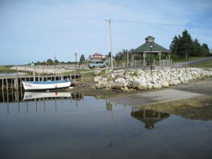
 Location: North East Point
Shoreline: sand
Type of access: gravel road
Parking: yes
Topographic reference: 20p/12 (Pubnico)
Marine chart # 4241(Lockeport-Cape Sable)
UTM grid:Â E0289044 Â N4820875
Latitude: N 43° 30.766’/Longitude: W 65° 36.547
Cape Sable Island has only been connected to the mainland by the causeway since 1949,up until that time travel to the island was made by boat or ferry.
Remains of the old ferry wharf timbers still standing in the sand as you paddle around the point makes for an awesome picture!
Launching your kayak from North East Point gives you many options for paddling in East Bay.Check your map for all your options
During the summer months you will find the Queen of Hearts Dory Club members practising for upcoming dory races. Come by Tuesday evening for Fun Night and you can try your hand at rowing a traditional style dory.
A walk around the point of the beautiful white sand beach will give you a view of East Bay about 1 kil distance. At this site some of the local sailors have their sailboats berthed.
