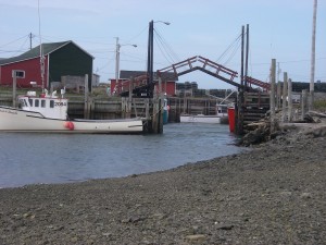
02. Sandford


Location: Sandford Breakwater
Shoreline: gravel
Type of access: paved and gravel road
Parking: Yes
Government wharf: Yes
Public slipway: No
Public concrete ramp: No
Topographic Reference: 20-0/16 (Yarmouth)
Marine Chart#:4243 Tusket-Cape Saint Mary’s
UTM Grid: 28/60
Latitude:N 43° 55.113’/Longitude:W 66° 09.260′
Â
A photographer’s delight! Sandford lays claim to having the world’s smallest working drawbridge, allowing boats to come in through the channel.When taking the Sandford Breakwater Road, keep right and parking is available. Access to the water is between the breakwater and the buildings. A more unique paddle would be at high tide to put your kayak in where the channel comes up to the road and paddle out through the channel and under the draw bridge.Keep left on paved road to wharf for this access


