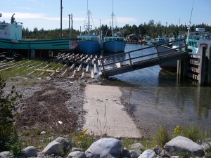
 Location: Government Road (Gordon Point Wharf )
Shoreline: rocky
Type of access: gravel road to government wharf
Parking : yes
Government wharf: yes
Public slipway: no
Public concrete ramp: yes
Topographic reference:20p/11(Lockeport)
Marine chart #: 4241 (Lockeport-Cape Sable)
UTM grid: E0325395 Â N4842827
Latitude : N 43° 43.188′ /Longitude: W 65° 10.008’Â
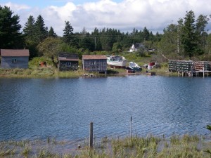
No amenities in West Green Harbour, exposed coastline and shoals between Blue Island and Pattersons Point .This launch site is very sheltered. Along one shore it is dotted with old buildings from bygone days, a photographer’s delight.
Location: Off of West Green HarbourShoreline: mostly rocky except on Northern end of island in the cove where it is suitable to land
Type of access: only by boat
Parking: West Green Harbour
Government wharf: n/a
Public slipway: n/a
Public concrete ramp: n/a
Topographic reference: 20 p/11(Lockeport)
Marine chart # 4241(Lockeport-Cape Sable)
UTM grid: E0324706 N4839112
Lat/Lon:
Name of owner:
Private exit: Yes
Private access: Yes
The owner of this beautiful and rugged island has given permission for kayakers to use this island for overnight tenting if passing through the area and need a place to overnight before paddling along the coast further or for emergency landing. You may make a campfire near the tide line.
There is a shelter and outhouse on the north end of the island and a safe cove here for landing. Please respect the property and “take pictures and leave only footprintsâ€
There is a narrow path along the west side well worn by sheep that live on the island, this is a very interesting and rugged walk to the south end of the island. Besides sheep living on Blue Island there are a few Highland Cattle.
It is possible to land in Blackbeards Cove if wind conditions allow.
