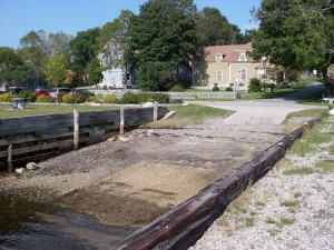
 Location: Dock Street, Shelburne waterfront
Shoreline: rocky
Type of access: paved road
Parking: yes
Public concrete ramp: yes
Topographic reference: 20p/14(Shelburne)
Marine chart # 4241 (Lockeport-Cape Sable) or 4209 (Lockeport and Shelburne Harbour)
UTM grid: Â E0312897 Â N4847585
Latitude: N 43° 45.567’  /Longitude: W 65° 19.410′
Name of owner: Town of Shelburne
Take time to stroll along Historic Dock Street while in town, visit Shelburne Historic Complex before hitting the water.
The Town of Shelburne is a very busy town especially along the waterfront, sailing, kayaking, museums, longboats, yacht club or stroll along the water front and enjoy a beautiful sunset on the the third largest harbour in the world There are several launch and offshore sites in the Shelburne area. The Seadog Saloon on the waterfront rents kayaks by the day or half day.In July Shelburne Founder Days adds extra bustle on the water front. Check out shelburne’s websites for more information: ww.discovershelburnecounty.com ,www.shelburnefoundersdays.com, The websitewww.municipalityofshelburne.ca has more information on the walking trails in the Municipality of the District of Shelburne. On August 17,18,19th 2012 Shelburne will host a Kayak Festival and other local activities to keep up to date check the website for a complete schedule.
Some of the places to stay in Shelburne that are easy to paddle to are located right along the coastline of Shelburne Harbour, other accommodations are nearby.
