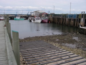
Location: Pinkney’s Point Wharf Shoreline: rocky Type of access: paved road Parking :yes Government wharf: yes Public slipway: yes Public concrete ramp: no, gravel access Topographic references: 20-0/9 Comeaus Hill Marine chart #4244 Wedgeport and vicinity UTM grid:07/37211 (37) 48/43077 (43) Latitude: N 43° 42.257’ / Longitude:W 66° 03.350′ Public access
Launching from Pinkney’s Point Wharf you can explore Little River Harbour, paddle over to Comeau’s Hill and then on out to the Tusket Islands. Paddling out to the Tusket Islands is not for the novice paddler. Be aware of the tide, wind and fog conditions.
Pinkney’s Point is reached by driving a 2km stretch of road winding through saltwater marshes. Have your binoculas handy, this is a good place to see shorebirds feeding. Pinkney’s Point is almost an island, a large breakwater along the road helps to protect the fishing boats at the wharf from  the Atlantic wind and waves.
There are no services along the road or in the village.

