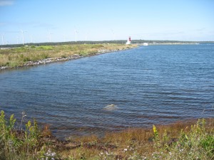
 Location:Â Charlesville/East Pubnico-Lighthouse Road
Shoreline: beach stone, gravel bar
Type of access: gravel road from highway, Lighthouse Road @ county line
Parking: limited
There are some boats pulled up here, only at high tide you can use this as a drop off or pick up site because of the gravel bar when the tide is low. When you are paddling this route it is possible to portage from one side of the road to the other instead of paddling around the lighthouse point if it is too windy.
Topographic reference: 20p/12 (Pubnico)
Marine chart # 4210 (Cape Sable -Pubnico Harbour)
UTM grid: E0275550 Â N4830558
Latitude:N 43° 35.763’ / Longitude:W 65° 46.771
Public access
A walking trail from Charlesville to Yarmouth (58 km) is now open.  A spectacular view of the ocean as you cross over bridges where railway trussles originally were . The flora , fauna and birds along the trail are both abundant and interesting to the naturalist. Check the kiosk at the beginning of the trail for more information.
