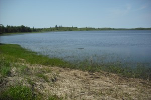
 Location: Next to Glenwood sign on highway 103 travelling from the easterly direction.
Shoreline: gravel/rocky
Type of access: Highway103 paved road
Parking: limited parking, along side of 103 highway
Topographic reference: 20 p/13 (Tusket)
Marine chart # 4244 (Wedgeport and vicinity)
UTM grid: E0269391 Â N4852662
Latitude: N 43° 47.672’/Longitude: W 65° 52.235′
Public use from the highways
Note:The Argyle River is tidal, keep in mind the tide times, a beautiful paddle up the river especially in the fall. This location makes a good access to the ocean by just paddling under the Argyle River Bridge on the highway.There is a fair bit of current when paddling past the pillars from the old bridge.
Caution: Impassable during low tides for access
While in this area if you are looking for a good picnic spot take the Glenwood 32A exit and continue on the #3 highway towards Yarmouth, Glenwood Provincial Park (no camping). There is also access to Rickers Lake, a good size lake if you want to experience an inland paddle for a bit of variety.
